Bhulekh System in India
A widely common land record phrase in India, bhulekh is also associated with online land record software in states such as Uttar Pradesh, Orissa, and Bihar, among others. Despite the fact that other states also have online land record software, they go by a different name.
During this blog post, we will cover the broad concept of Bhulekh, its definition, the contexts in which this term is used, and how to obtain a copy of this record in your jurisdiction.
What is Bhulekh?
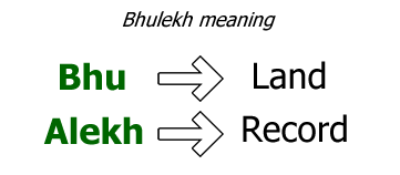
Bhulekh is a Hindi/Sanskrit word that literally translates as “Bhu” + “Alekh.” It is translated as “Land Record” in the English language. Bhu (Hindi) is a word that means “land” (English). Alekh (Hindi) is an abbreviation for record (English)
The history of Bhulekh in India dates back to the time of the Indus Civilization. A system of maintaining land records (bhulekh) existed throughout the Mughal Empire, and this system expanded and became more scientific under the British occupation of the country.
Since independence, the State Government has been responsible for the upkeep of these land records. In order to improve the accuracy and usability of the system, the central government financed the Computerization of Land Records (CLR) project in 1988-89.
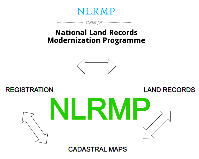
The National Land Records Modernization Programme (NLRMP) was launched by the Indian government in 2008 with the goal of developing a contemporary, comprehensive, and transparent land records management system throughout the country. States are digitizing Records of Rights (RoR) and other land information, such as maps, as part of the National Land Records Modernization Program (NLRMP) (bhu naksha).
Each state maintains its own bhulekh website, which allows anybody to access land record information on the internet at any time. Using the Bhulekh service system, one may have access to Land Records such as Khasra-khatauni (Land Deed), jamabandi (Record of Rights), copy of jamabandi (nakal), fard, and other similar documents.
What is Khasra Khatauni Exactly?
Khasra: A khasra is a legal agricultural document used in India that describes the location of the land and the crops that will be grown on it. “All of the fields and their areas, measurement, who owns the property and what cultivators he uses, what crops are grown there, what kind of soil is there, and what trees are on the land,” according to traditional use.
Khasra Numbers are land parcel identification numbers assigned by the state’s revenue department to identify specific parcels of land. It is envisaged that this number would be unique inside a community. If it is not unique, contact your local land record office or the National Institute of Standards and Technology to get it corrected.
In the village of Khasras, an abstract is created that details all of a person or family’s assets in that village. A khatauni is based on the khasras of the village and is based on an individual or family’s holdings in that village. Therefore, the khatauni of an individual will have information on all of the khasras that are associated with that individual.
Jamabandi: A village’s land Record of Rights (ROR) is referred to as a jamabandi. There are several sections in the Jamabandi Register, including the names of landowners as well as the area of the property, the number of shares held by the landowners, additional rights, cultivation, rent and revenue, and other taxes payable on the land. Fard, parcha, and many more variations are used in different parts of the world, but the most frequent term is Jamabandi in North America and the United Kingdom.
Land Records from Bhulekh UP
Finding land-related information, such as records of right, fard, Khasrakhatauni, Bhu naksha, and other relevant data was extremely difficult to come by. The development of a website by the NLRMP programme has provided a solution to this challenge. The National Informatics Center is in charge of developing the website (NIC Lucknow).
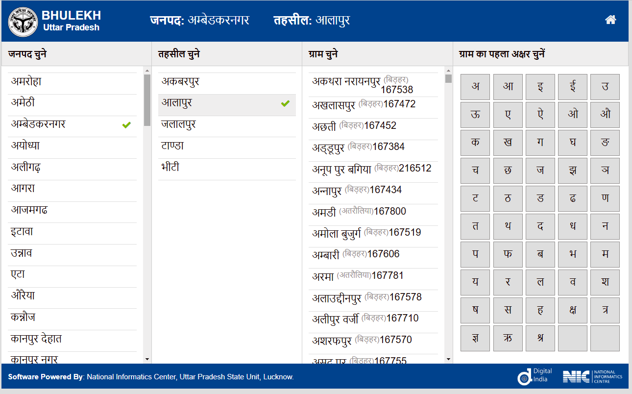
The website is in Hindi and features a user interface that is very simple to use. After filtering by district, tehsil, and village, one may search for bhulekh using the Khasra number or the khata number or by name.
How to check online land records (Bhulekh) in the state of Uttar Pradesh?
- Go to the Bhulekh UP official website (https://bhulekh.up.nic.in) to get started with the process. Then select ‘Disctricts’ from the drop-down menu. On the left-hand side of the page, you can find the names of the many districts.
- Choose your district from the drop-down menu. When you choose a district from the website’s list, the website displays the tehsil names for the district you’ve chosen.
- It is now necessary to choose your tehsil name. It will display the village names of the selected tehsil once you have picked the tehsil’s name from the list.
- The next step is to choose the village name and then click on the “search” button to proceed.
- You may now do a land records search using any of the three options listed below.
- The number of Khasra.
- Khata number
- Name
On the website, you can get a list of districts in Uttar Pradesh where you may look for land records.
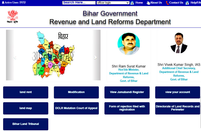
Land Records of Bhulekh and Bihar

The state of Bihar is digitizing its land records (khata khasara) in accordance with the Central Government’s National Land Record Modernization Program (NLRMP) initiative, similar to the state of Uttar Pradesh. The official website of Bihar’s revenue and land reform department, lrc.bih.nic.in/ror.aspx, has been updated with land records in 31 of the state’s 38 districts, according to the latest information available today (khata Khasara).
In Bihar, how can you look for land records (Bhulekh) on the internet?
- To begin, navigate to the following URL: https://biharbhumi.bihar.gov.in/Biharbhumi/
- Choose your district from the Bihar map at the top of the page. Once you have selected your district, the list of Anchals in your district will appear.
- Locate your selected Anchal on the map and click on it.
- After picking the Anchal, the list of all Mouza will appear on the left-hand side of the screen.
- There are two options for choosing mouza:
- You may either choose the mouza from the list or create your own.
- You may narrow down the mouza list by selecting one of the alphabets on the right side.
- To search your land records, you will be presented with a number of various search possibilities; choose one of the searching options.
- Look through all of Khatas’s recordings from a certain Mouza.
- Look through all of the records by Khata numbers from a certain Mouza.
- Take note of the Khata Number.
- Look for it by the Khasra Number.
- Look for the owner of the Khata by his or her name.
- Following your selection of the choices, click on the search (Khata Khoje) button to begin the search process.
- Once you have your land information, you may print off a copy of the document.
What does the legal value of Bhulekh Appear to be?
Bhulekh is an extremely significant and user-friendly system for maintaining land records, and it is quite beneficial for a variety of reasons.
- In order to resolve legal disputes or to deal with other legal matters.
- To either sell or purchase a piece of land.
- To open a bank account is to make a financial commitment.
- In order to obtain a loan from a bank or other financial institution.
- In order to maintain a personal record of the property.
- To subdivide a piece of land, which is referred to as a subdivision of land.
- To determine and track the state of an alteration, also known as the mutation status.