Land disputes and ownership concerns have emerged in India mostly as a result of inadequate record-keeping and administration. As a result, the Indian government has begun to digitize everything, including the property registration procedure and land records administration, in order to take advantage of increased access to technology. As a result, a property buyer may now view and check all land or property data with a single click of a mouse.
It is a critical step in avoiding any fraudulent transactions from taking place. The Delhi administration completed the digitization of land records in around 192 villages out of a total of 224 villages in the city in March of this year. According to the tax department, several further villages will be added as soon as difficulties that are preventing the computerization of land records in 32 villages are overcome, which should happen shortly.
The digitally signed records of rights (RoR) are available in the public domain 24 hours a day, seven days a week and can be accessed by people from any location.
What are land records, and how do they work?
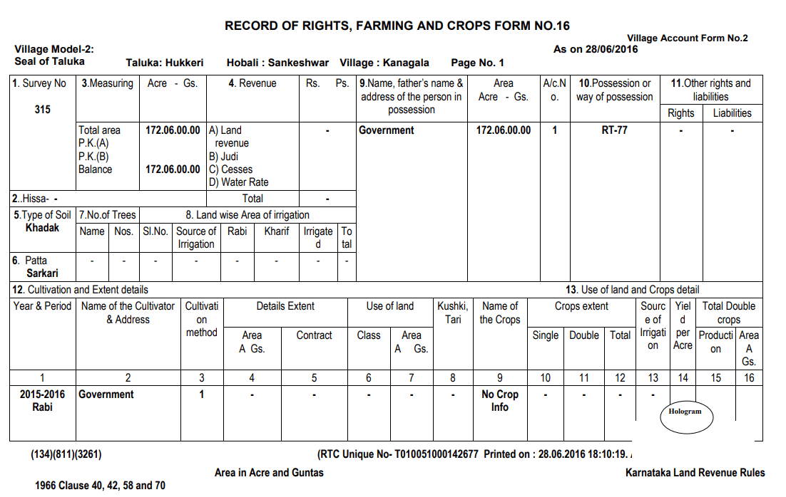
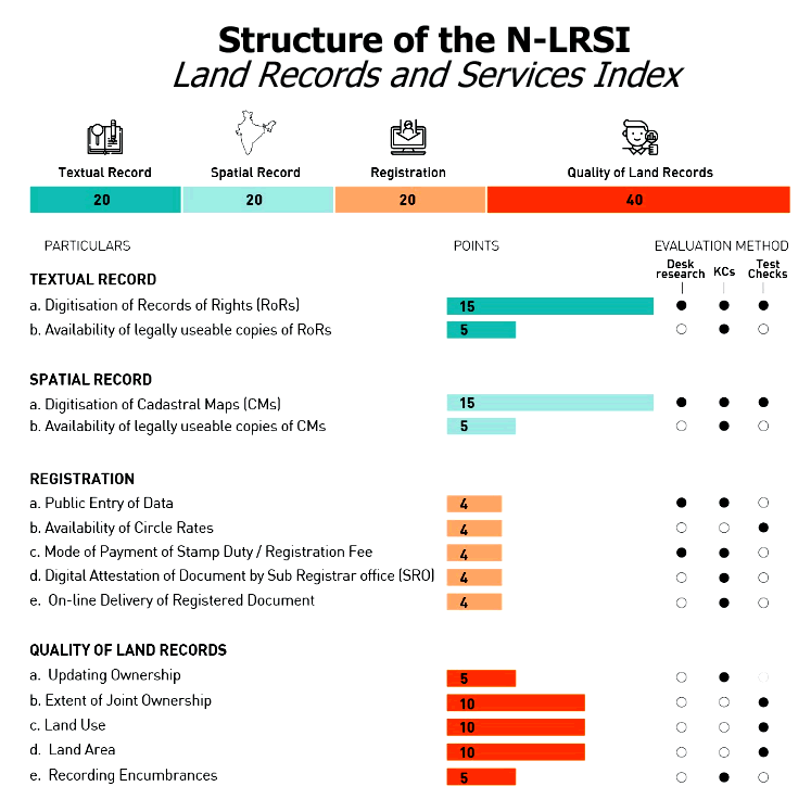
A larger phrase that encompasses the registration of lands, Records of Rights (RoRs), the tenancy and crop inspection register, the mutation register, and the contested cases register, among other things, is “land records.” Aside from that, there is geological information about the shape, size, and soil type of the property, as well as economic information on irrigation and crop production.
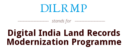
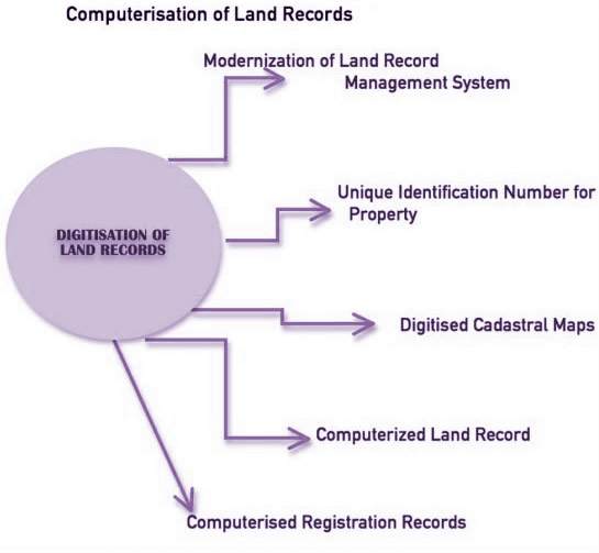
The National Land Records Modernization Program (now known as the Digital India Land Records Modernization Program, or DILRMP) was initiated by the national government in August 2008, and it continues to this day. All land records, including mutations, are being computerized.
Other aspects of the programme include the digitization of maps, the integration of textual and spatial data, survey/re-survey, and the updating of all survey and settlement records, including the creation of original cadastral records where necessary, the computerization of registration and its integration with the land records maintenance system, the development of a core Geospatial Information System (GIS), and capacity building.
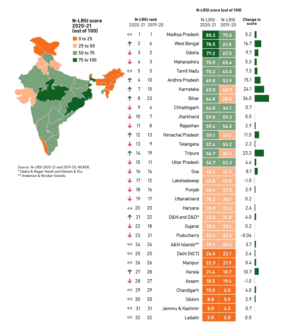
Many Indian states have digitized their land records, which is a good thing. Rajasthan, Chhattisgarh, Haryana, Himachal Pradesh, Karnataka, Kerala, Madhya Pradesh, Odisha, Uttar Pradesh, Uttarakhand, and West Bengal are among the states that fall under this category.
The Delhi government has also begun digitizing land records, which are also known as Bhulekh, Khasra, or Khata details, according to the local dialect. Information regarding 1,80,000 Khasra and 78,000 properties have been recorded online as part of the Delhi Land Record Online initiative.
What is the best way to check your land records?
Take, for instance, the following scenario. The following are the specifics of a plot of land in Delhi: Khata Number 10, Asalat Pur Khawad, Kapashera, South West Delhi, and New Delhi are few of the areas where you may stay.
- Step 1: Navigate to the Land Records Department’s official website in your state to begin. For Delhi, go to the following website: https://www.dlrc.delhigovt.nic.in/index.html.
- Step 2: Decide on the district or sub-division in which the property will be located. In this particular instance, the land is located in the Kapashera district in the South West. Delhi.
- Step 3: Choose the tehsil or village, which is Asalat Pur khawad in the Asalat district. Then choose the Khata type from the drop-down menu. The Bhumidars are the people who own the land most of the time. Bhumidars are landowners who enjoy permanent, heritable, and transferable rights to their lands and who are not subject to the laws of succession. Asami refers to a group of tenants or sub-tenants who were tenants or sub-tenants of the Gaon Samaj. It is possible to inherit these rights, but they are neither permanent or transferable.
- Step 4: Using the Khasra Number or the name of the owner, you may do a search for more information. Khata Number 10 was the one we chose.
- In Step 5, select the option to View Khata Details in order to obtain the necessary information, which includes the amount of land owned by each owner, the Khasra number, and the size of the land. Remarks relevant to any loan taken out or property leased out are also included in a separate part of the report. In this particular instance, the document refers to a gift deed, which is a legal document that signifies the voluntary transfer of property without the exchange of money.
The benefits of digitizing land records
Access to land information is simplified thanks to an online database that allows individuals to check property land records and their legal status without having to make any personal trips to revenue offices.
They may cross-check the land status using the maps that have been put up to depict the ground condition, and they can bring their concerns to the attention of the authorities if there is any disagreement.
Transparency will be achieved by the implementation of a land-titling system with title guarantee in order to secure land records and make them tamper-proof, hence preventing conflicts and litigation. The goal is also to give correct land information to residents through a single point of contact while maintaining data integrity. Encumbrances and scams in the issuance of copies will also be monitored and investigated.
Maintenance will be simplified: While digitization reduces the possibility of any grievances arising as a result of delays, it will also facilitate the maintenance and updating of land databases.
Points to keep in mind
The following are some of the numerous details listed under the online land records:
- The name of the current owner, as well as his or her registered address.
- It specifies whether the land is agricultural, residential, a pass through which to travel, government-owned, wasteland, village property, or a commercial plot, among other things.
- Land parcels are measured and recorded (area in bighas).
- Any land-use change that has occurred in the past year.
- A mortgage is in effect, or a loan has been released on or against the land.
- Land transfers and other land-related transactions are defined as follows:
- Orders from the government concerning the land were issued.